A new picture of the world
To fly around the world while sitting at a computer and visualising the actual weather and environmental conditions - this is no
longer a fantasy. The necessary system solution for such an endeavour has been developed and successfully tested within the
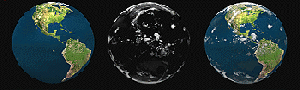
DeTeBerkom research project Terravision. The Terravision system enables the user to move interactively in three dimensions
over the entire earth surface in real-time. Terravision produces convincing results by an amazingly detailed and lifelike
representation of the earth's surface and atmosphere.
New Dimensions of Weather Forecast
One possible application of Terravision is 3-dimensional weather forecasting. The weather forecast is no longer presented to
the TV viewer as a map or view from a satellite. Instead the viewer moves in three dimensions through a virtual weather
landscape which is calculated from data throughout the world by high-performance computers at any time. Several international
broadcasting stations have already signalled their interest in the new application.
Project partners
Deutsche Telekom has been carrying out several projects within the BERKOM-programme as well
as in international activities in differentapplication areas with its subsidiary DeTeBerkom GmbH
since 1986. An example for this is the area of Infosystems and Telecomputing where Terravision is
a part of.
Project partner is ART+COM e.V., Berlin assisted by the Japanese firmWeathernews, Inc.
| 
 Terravision